Question
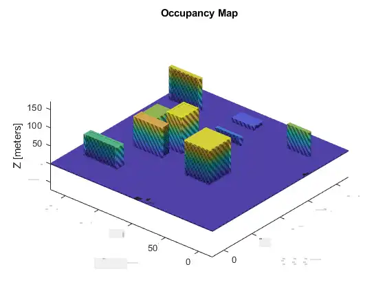
I want to create a 3D occupancy map to model a region where I want to test some path planning algorithms for an UAV. The matlab function requires some points and sensor pose to create the map, The example is poorly written and I am not able to understand how can I control the height, width and breadth of the buildings. Can some please detail the process of map creation perhaps for the following figure from MATLAB example? It shows various building with varying dimensions, I want to know how can I create this data file.
Expert Answer

John Williams
PhD Expert
Answered Oct 3, 2026
This way, through surf plot?: I have shown with random test data. You may adjust the colors of the pattern/area
data=zeros(500,500);
data(100:300,100:300)=10;
data(300:400,300:400)=20;
fig=surf(data);
set(fig,'LineStyle','none');
axis tight;
Note: Theare is a function in Matlab as occupancymap
100% Run Guarantee
3-Hour Fast-Track Delivery
Need a Custom Version or Complete Simulation for This Problem?
Our 500+ PhD engineers build, debug, and optimize working MATLAB scripts and Simulink (.slx) models tailored to your exact assignment rubrics with zero plagiarism.
Tested on MATLAB R2024b / R2026a
Turnitin 0% Plagiarism Report
Free 7-Day Revisions Guarantee
Have a different question? Ask here
Related occupancy grid Questions & Solutions
Browse All →
Explore similar technical troubleshooting questions and verified MATLAB solutions:
Ready-to-Run MATLAB & Simulink Projects
Browse All Projects →